Showing posts with label Cartography. Show all posts

Monday, February 4, 2013

Lattitude & longitude


Could you imagine if there were a bunch of lines all over the Earth,
that people could use to make maps and figure out where things were at on the planet?

Well there aren't really lines, but people have made up imaginary lines called latitude and longitude.
latitude longitude
(from: wikipedia - latitude)

latitude is the word we use for the lines that go side to side,
and longitude is for the lines that go up and down.

Using those lines you can tell exactly where a place is on the map!

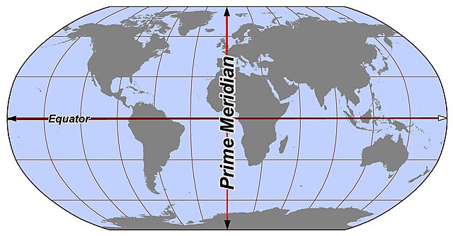
For latitude, the equator is in the middle so it is at 0° latitude.
The North pole is at 90° (or 90°N), and the South pole is at -90° (or 90°S).

For longitude, the 0° mark is at the prime meridian.
You can go East all the way to 180° (or 180°E) and West all the way to -180° (or 180°W).

For example, Detroit, MI is located at: 42.35, -83.05

Monday, January 28, 2013

Prime Meridian


We just learned about the Arctic Ocean

We learned that the middle of the earth halfway between North and South
is called the equator.

If we want to draw a line like that from the top of the map to the bottom,
to split it into East and West we use the Prime Meridian.
prime meridian
(from: wikipedia - prime meridian)

The main location on the map where the prime meridian is marked is a place called
the Royal Observatory Greenwich, in London England.

Monday, November 26, 2012

Equator


The middle of the earth, half way between North and South is called the equator.

The north and south parts of the earth are called hemispheres.

(From: Wikipedia - Equator)

The weather is always hot on the equator because that is where the sun's rays shine most directly on the earth.

Monday, October 29, 2012

Cardinal Directions


We just learned a little about the North America Continent.

On a map, if you see the letters N, E, S, W they stand for North, East, South, West.
Those are called the cardinal directions, and they are used to tell where something is at on a map.
cardinal
(From: Wikipedia - cardinal direction)

So if you are in Michigan, you might say that it's very cold up North and very warm down South.
New York is to the East, and California is to the West.

A fun way to remember the letters is the sentence: Never Eat Soggy Waffles!

world map

(From: Wikipedia - world map)

You can use a special tool called a compass to figure out which way is North, no matter where you are!

compass
(From: Wikipedia - compass)

Monday, October 1, 2012

Peninsulas

A peninsula is some place where land is sticking out and is surrounded by water.

Lake Michigan has an upper peninsula and lower peninsula surrounded by the lakes.
michigan
(from: wikipedia - michigan)

And Florida is a peninsula sticking out into the ocean.
florida
(from: wikipedia - florida)